Mreža zavarovanih območij v Alpah
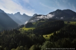
Located in the Swiss cantons of Vaud and Fribourg, stretching from the Vaud riviera (Montreux) to Bulle, from Gstaad to Gruyères, the Gruyère Pays d'Enhaut Regional Natural Park is an unspoiled rural area in the foothills of the Alps but has also been a popular tourist destination since the 19th century.
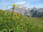
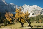
Most of the park lies between 800m and 2,000m above sea level. It is home to a patchwork of villages, hamlets, meadows, summer grazing, mountainous areas and woodland. The park boasts a wealth of different landscapes, wildlife and plant life. Outstanding biotopes and geotopes bear witness to the unspoiled nature of the zones that are so vital for a rich variety of flora and fauna, including the Vanil Noir, Pierreuse, and Étivaz valley reserves, all of which are managed by the Pro Natura organisation.
Dairy farming is the mainstay of agriculture with around 230 farms in the area (over 26 million kilos per annum). There are three registered cheeses: L'Étivaz AOC, Gruyère AOC and Vacherin Fribourgeois AOC. The regional economy is built around tourism (ski resorts, sports and leisure, hotels and second homes) with a variety of focal points in the area.
The Parc naturel régional Gruyère Pays-d’Enhaut association was formed in February 2006 with the aim of creating and managing a regional natural park. The organisation had two founding principles: compliance with the federal decree requiring local authorities to have decision-making powers and a commitment to involving local stakeholders. Thus the local authorities have more to contribute in terms of coordination and replication whilst the agricultural, tourism and business sectors will be involved in practical actions and projects.
In order to qualify for the "park of national importance" label, the project will be officially registered in January 2011 when the charter setting out the size and geographic area of the Park, its financing, activities and objectives is lodged. The charter comprises three documents: the Park contract (setting out the financial and strategic links between the local authorities and the association: boundaries, organisational structure and mandate, local authority funding), a description of the Park area and the management plan for the operational phase (the ten-year period covered by the park label, effective from 2011), which combines a ten-year plan and a four-year action plan.
Gruyère Pays-d’Enhaut Regional Natural Park
Place du Village 6
CH – 1660 Château-d’Œx
Tel. +41 26 924 76 93
Fax. +41 26 924 79 97
info@pnr-gp.ch
|
Name of protected area |
|
|
Managing body (if different) |
- |
|
Country |
Switzerland |
|
Area (ha) |
50 246 |
|
Year of creation |
2011 |
|
UICN category |
- |
|
Legal basis |
Proposal for regional natural park (park of national importance) |
|
Regions covered |
Fribourg canton (Jogne and Intyamon valleys), Vaud canton (Pays d'Enhaut, Rochers de Naye). |
|
Number of municipalities |
14 |
|
Highest point (m) |
2 548 |
|
Lowest point (m) |
372 |
|
Population |
12,585 inhabitants (2009) |
|
Forested land |
c. 20,000 ha |
|
Glacier |
0 ha |
|
Pasture land |
c. 17,000 ha |
|
Prevailing landscapes |
Landscapes typical of Alpine foothills made up largely of woodland, meadows, grazing, cliffs and scree. Combination of villages, hamlets and summer grazing land. |
|
Emblematic fauna |
Ibex, chamois, marmot, three-toed woodpecker, rock ptarmigan, black grouse and whinchat. |
|
Emblematic flora |
Narcissus radiiflorus, willow gentian, Alpine columbine, St Bruno's lily |
|
Major tourist attractions |
Château de Chillon, Le Grand Chalet de Rossinière (home of the painter Balthus), demonstrations of cheese-making (Col de Jaman, Maison de l'Etivaz), nature reserves (Vanil Noir, La Pierreuse, Vallée de l’Etivaz) |
|
Information centre(s) (quantity, name, topics) |
First information centre to be opened in spring 2011. Other visitor centres are planned and will be set up at key locations in the park. |
|
Website |
|
|
Number of employees |
6 plus interns |
|
Getting there |
From Bulle: TPF train (towards Montbovon) and Charmey bus. |
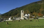
The Regional Nature Park Biosfera Val Müstair, UNESCO biosphere reserve since June 2010 (common with SNP) represents a sort natural of buffer zone for both of the old and important protected core zones of the National Parks Swiss and Stelvio/I. Since January 2011 it is recognized regional nature park of national importance.
This evolution is founded on a strong mobilization of its population, in which the acceptance of the nature Park was democratically approved in 2007 by 88%. One of the most important administrative steps was the unit of 6 municipalities since January 2009.
The various economic structures in Val Müstair are widespread; nevertheless tourism represents the highest potential of economic growth.
The intact landscape in Val Müstair offers a high quality of life. The river Rombach, one of the last free-flowing main valley rivers in Switzerland, and a high number of biologically-managed agricultural farms (80%) suggest a conscious and active cooperation of the valley inhabitants in the service of the natural resources.
The culture offer is also considerable: the internationally known UNESCO World Cultural Heritage St. Johann Monastery, an important number of museums and also the undamaged sites with the magnificent houses decorated with graffito are always a feast for the eyes for the visitor. The traditional language of Val Müstair is Romansch, to be precise “Jauer”. The language is officially spoken in everyday life and has remained alive up to the present.
AREVAIR IN VAL MÜSTAIR!
BIOSFERA…natüralmaing!
BIOSFERA VAL MÜSTAIR
Center da Biosfera - Chasa Cumünala
7532 Tschierv
Tel. +41 (0)8 18 50 09 09
Fax +41 (0)8 18 50 13 13
E-Mail: info@biosfera.ch
Homepage: www.biosfera.ch
Park's identity card: |
||||||||||||||||||||||||||||||||||||||||||||||||
|
||||||||||||||||||||||||||||||||||||||||||||||||
Further information:
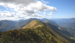
The Prealpi Giulie natural regional park extends across the territory of the villages of Resia, Resiutta, Chiusaforte, Lusevera, Venzone and Moggio Udinese within less than 100 km².
It includes the most elevated parts of the mountain ranges of the Plauris Mountain, Musi Mountains and the Canin Mountain, and slopes of altitude only in correspondence of the fraction of Povici and the Valley of the Mea stream.
These zones have been selected for their geological and natural importance, their landscape and as well the historical and cultural interest. They often present peculiar characters which are hardly founded anywhere else.
This is mostly owed to the fact that the protected area is in the intersection of three biogeographic areas (Alpine, Mediterranean and Illyric) but also to the border of the cultural Latin and Slavic worlds.
A particular specificity is represented in fact from the local communities settled in the Val Resia Valley and in the High Torre Valley have preserved their language and their traditions for centuries and contributed, with their laboriousness, to form the landscape of the territory of the protected area and its bordering zones.
“Stavoli”, “casere”, pathways, footbridges/catwalks, meadows and pastures constitute testimonies of a daily life, which has cohabited with the nature and moulded the territory day by day. Today it can be offered almost intact to the visitors and to the mountain lovers.
An important characteristic of the park is its transboundary vocation, which takes shape in the daily relationship with the Triglav National Park (Slovenia) but also, even if not so intense, with the National Park Nockberge (Austria).
In 2004 a project called ERA - Eco Regio Alpe Adria was launched in cooperation with these two parks. The aim of the project is to develop the cooperation in the sectors of the promotion of local products, of sustainable tourism and environmental education. One focus point is the school exchange project: every year children of local schools visit the other protected areas involved in the project.
To testify the strong connection with the Slovenian Park, the recognition from Europarc for a transboundary protected area arrived in 2009. This area, that includes the territories of the two parks and those of MAB Unesco Julian Alps in Slovenia as well. This area is called Julian Alps Ecoregion.
An ambitious result but also an objective for the future is to look at the progressive strengthening of the relationship among these territories and at the extreme naturalistic importance among the oriental Alps, which isn’t considered by any political and administrative differences, just as already many times wished by Alparc. With the Alparc network a profitable relationship of partnership, that developed collaborations in almost all the subjects but particularly in environmental education and eco-balances, is established. Therefore a special steering group for eco-balances has been created and coordinated by the Park of the Prealpi Giulie in cooperation with the Friulian Dolomites and of the Orobie Valtellinesi .
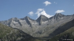
The Adamello Park covers an area of about 510 square kilometres on the Lombard side of the Adamello massif and along the valleys that descend from it as far as the Oglio river in Valle Camonica in the Province of Brescia.
The Park stands within the administrative areas of 19 Municipalities. About 6,000 people live within its limits. The running of the Park has been entrusted by the Lombardy Region to the Comunità Montana di Valle Camonica (Valle Camonica Territorial Community), based at Breno, which is where the Park’s administrative and technical offices are also located.
The feature that impressively dominates the higher part of the Adamello is the presence of glaciers. Because of current climate change and the consequent retreat of glaciers in mountains throughout the world, leading to their reduction or even disappearance, the Adamello glacier has lost the imposing size it had at the start of the 18th century, but the spectacle it offers today is nevertheless awe-inspiring: the Adamello glacier is up to 250 metres deep.
The conditions of relative isolation and impenetrability of the Park’s northern valleys encourage the presence of fine and interesting fauna: ibex and chamois, red and roe deer, rock ptarmigan, black grouse and golden eagles live on the most inaccessible ledges and in the best-preserved parcels of forest. And bears too increasingly frequent the Park’s valleys, having extended their range from the neighbouring Adamello Brenta Park in the Trento Region, where they have been reintroduced. It is to be expected that wolves and lynxes will soon be reappearing too.
About 40% of the Park is covered in wood and forest.
The most important forest on the Lombard side of the Adamello massif comprises a wide variety of species and conformations, influenced more by the slopes on which they grow and by the climate than by the composition of the soil or by human activity.
Within the Park, some drying houses and storerooms for chestnuts are still used and can often be visited, and there are also watermills where the chestnuts used to be ground to make flour.
The Valle Camonica is also famous for offering the greatest European concentration of prehistoric rock carvings: thousands of rocks carved over a period of over 6,000 years offer an account of the life of the Camunni people who lived in the valley in pre-Roman times.
The Valle Camonica is this too: nature and culture fused together to form a site of extraordinary importance right in the heart of the Alps, a “World heritage site” that remains to be discovered and valued to the full by many citizens of Europe.
Text by: Dario Furlanetto, Director of the Adamello NaturalPark
Park details |
|
Name of protected area |
 |
|
Managing enterprise (if different) |
Comunità montana di Valle Camonica |
|
Country |
Italy |
|
Area (ha) |
51.000 ha |
|
Year of creation |
1983 |
|
UICN category |
V |
|
Legal basis |
Regional Park |
|
Regions concerned |
Lombardy |
|
Number of municipalities |
19 |
|
Lowest point (m) |
m 390 |
|
Highest point (m) |
m 3539 |
|
Population |
6.000 inhabitants |
|
Forest surface area |
Ha 15.600 |
|
Glacier surface area |
Ha 15.000 |
|
Pasture surface area |
Ha 4.380 |
|
Prevailing landscape types |
Deciduous and coniferous forest |
|
Emblematic fauna |
Ibex, chamois, bear, golden eagle, eagle owl, Western capercaillie, black grouse, rock ptarmigan, rock partridge. |
|
Emblematic flora |
Pinus uncinata, Pinus cembra, Genziana puntata, Primula daonensis, Leontopodium alpinum, Campanula raineri, Vaccinum microcarpum, Lycopodiella inondata, Andromeda polifonia, Drosera angelica, Artemisia genepì, Cypripedium calceolus. |
|
Major tourist attractions |
Ponte di Legno - Tonale ski area, Prehistoric rock carvings of Capo di Ponte and at Unesco 94 site, Boario Spa. |
|
Information centre(s) (number, name, themes) |
Vezza d’Oglio, Via Nazionale 132 – postcode 25059 - tel 0364/76165 |
|
Internet site |
|
|
Number of employees |
9 people |
|
Access BY CAR |
from Milan, take the SS 42 road to Passo del Tonale; from Bolzano, take the SS 42 to the Passo del Tonale; from Brescia, take the SP 510 as far as Pisogne, then continue on the SS 42. |
The nature park Weißbach is situated between Loferer, Leoganger and Reiter Steinbergen in the region of Salzburg (A) and is bounded to the nature reserve “Northern Kalkhochalpen” on the Salzburg side and to Bavaria by the national park and, respectively, by the biosphere reserve Berchtesgaden .
In 2011, the XI Alpine Conference nominated this alliance of the protected areas „Berchtesgaden-Salzburg” as a pilot region for the ecological Alpine network. The trans-boundary cooperation between protected areas is an important aspect and is shown in various projects like cross-border hiking events or common design of information points in the border area.
Next to the natural monument Seisenbergklamm, the significant landscape elements are different types of mountain forest, Alpine pastures and rock heaps.
In this landscape mosaic of the nature park, which was created in 2007, you can find many species, partly protected, of animals and plants as various types of gentian and orchids (yellow gentian as the basis for the traditional Kallbrunner gentian schnapps), different butterfly species (Apollo) or the Golden Eagle.
The Alpine pastures are farmed for more than 600 years and are the fundament of local products and sustainable tourist offers. Characteristic for this region are the agricultural communities of Bavarian farmers and those of the Salzburg area. In cooperation with the nature park, they developed the information point on the Alpine pasture Kallbrunn and guided theme hikes. Furthermore the community offers culinary events as the Alpine pasture cheese Kallbrunn.
Next to the awareness raising measures as the visitors program and a nature workshop, the association of the nature park Weissbach strengths, since 2011, the cooperation with its disseminators. Local and organic farmers, selected by special criteria, support the idea of the Nature Park and use the weekly market day, established in January 2012, as a communication platform between producers and consumers.
|
Name of protected area |
The nature park Weißbach
|
|
Managing enterprise |
Association nature park Weißbach |
|
Country |
Austria |
|
Area (ha) |
2778 ha |
|
Year of creation |
2007 |
|
Legal basis |
protected landscape area with the labbeling as nature park, partly in the nature protected area Northern Kalkhochalpen (NATURA 2000) and natural monument Seisenbergklamm |
|
Included regions |
Salzburger Saalachtal / Pinzgau / Austria |
|
Number of municipalities |
2 |
|
Lowest point (m) |
665 m (Weißbach Ort) |
|
Highest point (m) |
1953 m (Hochkranz) |
|
Population |
main part of the nature park is uninhabited, around 50 inhabitants (without the farmers of the Aline pastures) |
|
Forest surface |
2084,7 ha |
|
Pasture surface |
310,5 ha |
|
Prevailing landscape types |
gorge with ravine forest, mixed mountain forest, mountain meadows, Alpine pastures, Alpine meadowy phytocenoses of grass, small bogs, near-natural flowing waters, rock heaps |
|
Emblematic fauna |
would grouse and black grouse, snow grouse, Golden Eagle, various butterfly species as the Apollo butterfly, chamois and red deer |
|
Emblematic flora |
species of gentian as purple gentian, species of orchids as vanilla orchids or Lady's Slipper, Turk's Cup Lily, ferns as Hart's-tongue fern, Stone pine, larch tree and fir tree |
|
Major touristic attractions |
natural monument Seisenbergklamm, Alpine pasture Kallbrunn, Hirschbichl (border to the Berchtesgaden national park), natural experience way Walden, forest experience path, Alpine pasture experience bus |
|
Information center(s) |
1) Informationcentre of the nature park Weißbach with information of the park 2) Alpine pasture Kallbrunn - chees dairy with information of the Alpine dairy and the alliance wwith the Berchtesgaden national park |
|
Internet site |
|
|
Number of employees |
1 |
|
Access |
The bus 260 is running between the City of Salzburg and Zell/See or Saalfelden (connection also to the train). Via car you should use the federal highway B311. |
The Alpine Park Karwendel encompasses almost all of the Karwendel range. Extending over 727 km², the park is the largest protected area in the state of Tyrol and Austria's largest nature park. The area’s exceptional conservation value was recognised very early on. Tyrol’s oldest protected area first came into being when the central section of the Karwendel massif was made a conservation area back in 1928. The climate and topography have endowed the Karwendel range with an unusually high number of natural habitats such as ancient woodlands and wild rivers (Isar and Rißbach).
The massif is also home to a wide variety of species. Many typical Alpine flora and fauna are very common here, including golden eagles, sandpipers and German tamarisk (Mycaria germanica). The Karwendel range has been a destination for Alpine tourists for over 130 years and receives around one million visitors every year.
Traditional farming practices – including Alpine dairy farming, forest management and hunting –play a vital role and have been an integral part of the region's identity for centuries.
The role of the park management
The park management body is an essential factor in making formal conservation commitments issues a reality on the ground for regional stakeholder. To this end, the Alpine Park Karwendel Association (Verein Alpenpark Karwendel) was created in January 2008, a body which brings together the federal state of Tyrol, all the relevant local authorities, tourism federations, the Austrian Federal Forests service, chambers of agriculture and the Austrian Alpine Club. The park’s activities focus on:
The top priority for conservation is maintaining natural rhythms and diversity in the Alps. Projects designed to do that include establishing reserves of ancient woodland, maintaining natural wild watercourses, returning the Karwendel marshes in the Achen valley to their natural state, and the Rißtal sandpiper conservation programme.
Interactions between visitors and the park are intended to develop awareness and a love of Nature, thereby ensuring its preservation. Visitors can learn about the Alpine Park Karwendel at the Hinterriß visitor centre and can also take part in a variety of organised activities. Four park rangers are always out and about in the park during the summer with a view to encouraging contact between visitors and locals.
A wide-ranging environmental education programme has been developed as part of the park's natural sciences education activities, with courses lasting anything from half a day to five days. The courses look at key issues in the Karwendel park: biodiversity, water, life in the high mountains, Alpine dairy farming, forest management and more.
|
Name of protected area |
Karwendel Alpine Park
|
|
Managing enterprise (if different)
|
Karwendel Alpine Park Association
|
|
Country
|
Austria
|
|
Area (ha)
|
72 700
|
|
Year of creation
|
17/02/1928 – 1st protection order; 1995 – Natura 2000; 2010 - The alpine Park got the label "Nature Park"
|
|
UICN category
|
3 natural reserves, 6 protected areas, 2 calm zones
|
|
Legal basis
|
Association
|
|
Included regions
|
Tyrol/ Austria
|
|
Number of municipalities
|
15
|
|
Highest point (m)
|
About 800m
|
|
Lowest point (m)
|
Birkkarspitze (2.749 m)
|
|
Population
|
The largest part of the territory is uninhabited, the park counts 46 permanent habitants; it has about 1 million visitors per year
|
|
Forest surface
|
50%
|
|
Glacier surface
|
0%
|
|
Pasture surface
|
101 mountain pastures (about 10.000 ha of alpine pasture surface)
|
|
Prevailing landscape types
|
Mountain pastures, some areas of mountain torrent are very wild (Isar, Rissbach), mixed mountain forests.
|
|
Emblematic fauna
|
Eagles, chamois, common sandpiper, 2.200 caleoptera species (beetle), 700 butterfly species.
|
|
Emblematic flora
|
German Tamarisk, sycamore maple, tipical alpine flora with numerous species of gentiana and orchid families such as the "lady's slipper orchid"
|
|
Major touristic attractions
|
Great and small Ahornboden, Isar spring (Hinterautal), Laliderer wall (Hinterriß), Hafelekar - a "window" which looks out onto the Karwendel mountains (Innsbruck), Wolfsklamm gorge (Stans), Halltal (Absam)
|
|
Information center(s) (quanitity, name, topics)
|
Hinterriß park's house with pedagogical spaces on subjects such as hunting activities, fauna, geology, water, history and alpinism.
|
|
Internet site
|
www.karwendel.org
|
|
Number of employees
|
3 - 4 personnes
|
|
Access
|
By car: since Innsbruck take the A12 (also called E60, see E45) in direction of Salzburg, issue Jenbach then follow Achenseerstraße. Go on in the direction of Maurach s/Achensee, then take the B181 direction Germania, cross Bavaria (the road number is B307), follow in the direction of Lenggries. Arrived at Sylvensteinspeicher, turn to the left in the direction of Fall, Vorderis (always on 307). At Vorderriss, take the left in the direction of hinterriss and go on 10km. The park’s house is in the entry of the village, just after the former customs, on the right. |
"My clime-mate" is an international exchange programme that is part of the dynAlp-climate project, which is focussed on climate issues. The programme is the brainchild of the "Alliance in Alps " network of local authorities and "Youth in Action ", which also fund the project.
The programme brings together young people from 10 municipalities which are members of the Alliance in the Alps. The young people considered the subject of climate change in the Alps, planned meetings and set up joint climate-related activities.
Young people from Austria, France, Italy, Slovenia and Switzerland were actively involved in the project, organising a wide range of events and activities. They also set up exchange schemes, which provided an opportunity to discuss the subject in detail
At the end of October, all the young people and moderators gathered in Sörenberg (Switzerland) for the final meeting. They compared notes on their expereiences and discussed where to go next as the programme drew to an end
For more information, go to http://www.alpenallianz.org
Source: Youth summit on climate issues, Entlebuch (German, French, Italian)
“How renewable are the Alps?”
“What are the renewable resources the Alps can build a future on?”
“How can a sustainable future be built on past experiences and know-how?”
These questions will be addressed during the third Alpweek taking place in Valposchiavo, Switzerland, 5-8 September 2012 . All those who are engaged in and for the Alps are invited to contribute to a manifold of discussions and presentations from different perspectives, ranging from nature protection to demographical issues. The key role of future generations will be a main feature of the event.
Climate Change and anthropogenic activities are challenging European habitats and their management.Especially protected areas are confronted with the pressing need to monitor changes, adapt management strategies and consider flexible responses to future developments.
The aim of the conference is to bring together researchers, conservation managers and decision-makers in the field of nature conservation.It provides a platform for dialogue to develop a better understanding of the complex impacts of climate change on biodiversity on local level and the means to adapt management in protected areas accordingly.
We anticipate 150 international participants to enjoy two days of technical sessions, workshops, poster exhibits and social activities, and one day of excursions.
Topics:
One of the conference aims is to found the association "Climate Change and Protected Areas". This association should serve as a sustainable network for transdisciplinary exchange of experts in this field.
For further information, please click on the following link: http://www.habit-change.eu/index.php?id=200
Conférences, ateliers, films et débats, avec la participation de Nicolas HULOT.
Le 8 octobre : soirée dédiée aux Réserves naturelles de Haute-Savoie, avec le directeur d'ASTERS et la projection du film "Les Alpes, les sommets de l'extrême".
Programme complet en ligne (PDF)
Plus d'informations: www.rencontresalpines.org
- Strategies for the Alpine Region -
Conference location: Bavarian Academy of Sciences and Humanities
Alfons-Goppel-Str. 11
80539 München, Germany
La Stratégie Biodiversité Suisse aspire, d’ici à 2020, à une société ayant suffisamment de connaissances sur la biodiversité pour être en mesure d’en prendre compte dans les décisions importantes.
Mais comment motiver les acteurs concernés d’intégrer la conservation et la promotion de la biodiversité dans leurs actes quotidiens ? Que faut-il savoir, et quel rôle jouent les valeurs, les images de la nature ou les possibilités de participation ? Ces questions seront abordées au congrès SWIFCOB 13 «La biodiversité, comprendre pour mieux agir» du Forum Biodiversité Suisse de la SCNAT à l’aide de théories modernes et d’exemples modèles implémentés. Nous vous invitons à vous inscrire pour une participation ou pour un stand à notre marché :
www.biodiversity.ch/f/events/swifcob/
SWIFCOB – Dialogue entre acteurs de la biodiversité
Le Swiss Forum on Conservation Biology SWIFCOB réunit les différents acteurs des sciences et de la société dans le domaine de la biodiversité. Le congrès est une plate-forme d’échange dédiée aux défis à relever en matière de biodiversité. En outre, SWIFCOB a pour vocation de susciter le débat autour de sujets d’actualité liés à cette thématique. Le Forum Biodiversité Suisse de l’Académie des sciences naturelles (SCNAT) organise chaque année le congrès avec le soutien et la collaboration de différents partenaires.