Mreža zavarovanih območij v Alpah
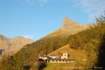
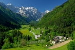
The Mont Avic nature park covers the area of approximately 5.800 hectares between the high alpine valleys of Champdepraz and Champorcher in the Italian region of Aosta Valley. Together with Gran Paradiso national park and Vanoise national park in France, it forms vast and one of the largest trans boundary protected areas in the Alps. Landscape types, which protection is rather poorly represented on the national level include high mountain ophiolite sites, mountain pine forests and peat bogs.
In the heart of the park there are many lakes that with its surroundings form a typical alpine landscape of great value.
The protected area preserves a wide variety of ecosystems and traditional agricultural activities, typical for alpine space. On high mountain pastures grazing cattle, and to a lesser extent sheep and goat is presented. In the early years of 20th century mining activities have gradually depleted forests.
In the last decades, the complete absence of economic exploitation of forests lead to its renewal. Consequently the presence of forest fauna improved (especially wood-eating insects, black woodpecker, boreal owl and Eurasian pygmy owl).
The park has acquired the labels SIC and ZPS, that safeguard habitats and species of particular interest. Among the most important ones we can mention the forest fauna, flora and fauna of less spread and therefore particularly vulnerable areas such as peat bogs and surfaces of serpentinite and schist rocks.
The Mont Avic nature park is the first protected area that obtained the label EMAS. European commission granted this certificate to the park in 2003. EMAS is an environment management system designed to encourage institutional, surveillance and other activities (especially agriculture and tourism) to undertake more appropriate environment treatment measures.
In order to promote proper visit to the park, more than 100 km of regularly maintained footpaths, accompanied with information panels and viewing points are arranged. In the visitor centre an interactive museum exhibition, devoted to habitats in the valley of Champdepraz is installed. A second visitor centre is currently in construction in the village of Champorcher, that will be design to present high altitude environments.
Park rangers and naturalist guides will provide guided and teaching visits. With nature conservation topics of internships, park welcomes students. On the web page www.montavic.it , you can find all further information, publications and full description of the park.
|
Name of protected area |
Nature Park Mont Avic |
|
Managing enterprise (if different) |
|
|
Country |
Italy |
|
Area (ha) |
5 800 |
|
Year of creation |
1989 |
|
UICN category |
IV (SIC-ZPS) and VI |
|
Legal basis |
Governed by public law |
|
Included regions |
Autonomous Region Valle d'Aosta |
|
Number of municipalities |
2 (Champdepraz - Champorcher) |
|
Lowest point (m) |
1 000 |
|
Highest point (m) |
3 185 |
|
Population |
Not permanently inhabitated |
|
Forest surface |
1.560 ha |
|
Glacier surface |
20 ha |
|
Pasture surface |
400 ha (with alpine meadows included) |
|
Prevailing landscape types |
High altitude rock sites, alpine meadows, lakes, peat bogs, subalpine and alpine pastures, forests |
|
Emblematic fauna |
black grouse, black woodpecker and more than 1150 species of butterflies |
|
Emblematic flora |
mountain pine, peat, flora on serpentinite and schist |
|
Major touristic attractions |
Lake landscape with tree covered rocks, cultural and technical heritage of mining and pasture, panoramic sights on Graian and Penine Alps |
|
Information center(s) (quanitity, name, topics) |
Info centre of Covarey (featuring the Alpine Network of protected areas and the areas included in the Park) |
|
Internet site |
|
|
Number of employees |
17 (of which 4 part-time) |
|
Access |
Highway A5 exit Verrès, then use regional roads in direction for Champdepraz or Champorcher |
The scientific group dedicated to research in the Swiss parks has been commissioned by the Swiss Federal Office for the Environment (FOEN) to create a thematic catalogue.
The catalogue covers themes pertaining to sustainable regional development, with a particular emphasis on comparative research in parks of national importance. This provides the basis for initiating cooperation between scientists, local, regional and national authorities, and park management bodies. It represents the first step towards developing a research strategy.
The catalogue can be downloaded in French or German at :
http://www.parkforschung.ch/downloads//Parkforschung_Themenkatalog_franz.pdf
http://www.parkforschung.ch/downloads//Parkforschung_Themenkatalog_deutsch.pdf
(Source: Research coordination in the Swiss parks)
Du 7 au 11 juillet 2012, le Parc national du Mercantour et Mountain Wilderness, association nationale de défense de la montagne, ont célébré dix ans de fructueuse collaboration sur les opérations « Installations Obsolètes ».
A cette occasion, plus de six tonnes d'installations militaires et agricoles obsolètes ont été évacuées de différents sites : sur la commune de Jausiers (Alpes-de-Haute-Provence) au lac des Sagnes, Granges communes et Restefond et sur la commune de Belvédère (Alpes-Marittimes) à la Cime de Tuor.
Une centaine de bénévoles de l'association âgés de 3 à 83 ans, des gardes du Parc et des éleveurs locaux se sont relayés durant le week-end sur les abords du lac et les pentes occupées par le troupeau du groupement pastoral pour extraire des lignes de barbelés, des déchets de casernement et ménagers agricoles.
Les chantiers de démontage co-organisés par Mountain Wilderness et le Parc national du Mercantour ont débuté en août 2002 dans le secteur de la Vésubie avec deux tonnes de déchets prélevées. Depuis, allant de Vésubie en Ubaye en passant par la Moyenne-Tinée, ce sont 153 tonnes au total, en métal principalement, qui ont été arrachées du sol, conditionnées et acheminées vers les différentes déchetteries. Ce travail entrepris sur 10 ans correspond à 2 700 journées de travail/homme.
Une « nouvelle » convention pour la pratique de l'alpinisme, de l'escalade et du canyoning a été signée cet été dans le Parc national des Ecrins .
Les « règles » que se donnent ses signataires restent dans l'esprit du partenariat engagé depuis plus de vingt ans dans les Écrins sur ce sujet. En effet, ce document réunit 9 partenaires autour des grands principes de défense d'une montagne sauvage : le Parc national des Écrins, la Fédération française de la montagne et de l'escalade, la Fédération française des clubs alpins et de montagne, la Compagnie des guides Oisans-Ecrins, Mountain Wilderness, l'Association des élus des communes du Parc national des Ecrins, le Syndicat national des gardiens de refuges et gîtes d'étape, l'Office national des forêts, le Ministère de la jeunesse et des sports.
Source et informations à ce lien .
Facilitating and supporting the creation of new enterprises is acknowledged as an important activity to maintain and reinforce the economic vitality of a territory and its enterprises. The Regional Nature Park Chartreuse is therefore encouraging and supporting the transfer of enterprises and the creation of new activities.
In partnership with the regional economic actors (intern and extern) the Park aims at support possible candidates with a project in Chartreuse in their efforts.
1) An individualised assistance in order to help the potential candidates in the development of their project
2) Facilitating the exchanges with potential support structures
3) Access to relevant socio-economic data for the territory
4) Help in the search of available premises
Further information:http://www.parc-chartreuse.net/vivre-en-chartreuse
Article 10 of the Tourism Protocol of the Alpine Convention foresees “the creation of quiet zones were no touristic infrastructure shall be developed”. Mountain Wilderness France has started working on this topic and published in 2008 the first French study on this subject. This study offers an analysis of various existing concepts as well as proposals for sites to be classified under this label based on a precise cartography.
Quiet zones are areas that present no particular interest from a strict biological point of view but they are exceptional and merit protection for their natural dimension, their particular calm and silence… their tranquility. They are conceived as new measure of landscape planning and their aim is to define areas were no infrastructure and other equipment should disturb the quiet of nature and man; their implementation should be done based on existing legal instruments.
In order to define , propose and implement this quiet zones Mountain Wilderness France has created an working group gathering actors like the Petzl Foundation, the Regions Rhône-Alpes and PACA, the national regional agencies, the Conservatoire régional des espaces naturels, regional and local politicians, WWF, CIPRA, ALPARC and others.
After several meetings and interviews with numerous stakeholders the working group has presented in July the first conclusions and defined the future orientations for the work. Generally the concept is well accepted and a common agreement of a wish to manage the territory according to new innovative way offering a harmonized relation between man and nature was identified.
Members of the network ALPARC as the Regional Nature Park Chartreuse for example are closely involved in these activities.
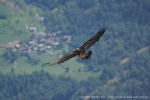
It is a great reward for the National Park Gran Paradiso and the Region Valle d’Aosta, both very proud of their contribution to this fantastic reintroduction project of a particularly emblematic species of the alpine fauna.
After almost 100 years of efforts both the National Park Gran Paradiso and the Region Valle d’Aosta, very symbolic locations of the nature protection history of the Alps, could celebrate a particular recompense and underline their pride of having actively contributed to this important action, whose aim was no less then to reintroduce to the mountain range a species that was since long absent of the Alps.
Champagne and Iris (that are the names given to the chicks by the scholars of the two valleys Valle di Rhêmes und Valsavarenche) were born in April 2012. Regarding the few individuals of the species present in the Alps this event can be considered as exceptionally, even more since the species is present in the western Alps only since a very short time thanks to the international reintroduction project.
Both birth and the successful take off of the young bearded vultures are for the National Park and the Region one of the most encouraging news of the latest bearded vulture protection history. With the salvation of the alpine ibex in the 19th century the National Park has not only ensured the conservation of one of the most symbolic figures of the alpine fauna but it has also laid the foundation for the comeback of the bearded vulture hundred years later, as this species is closely dependent on the food supply provided by a healthy ibex population.
Thus we have come full circle!
Between the prestigious Riviera and the high mountains of the Mercantour, this mountainous territory, composed of karst plateaus, gorges, forests and fertile valleys, the Préalpes d'Azur is still relatively unknown. There is a rural culture reigning, around picturesque, alive and convivial villages.
This is one of the territories of France's richest biodiversity; a third of the French flora is present there, the result of thousands of years of interaction between man and nature and always closely linked to the maintenance of pastoral activity.
The crossing of the Mediterranean and Alpine influences, together with an area which was preserved of major developments, make it exceptional. Added to this no less than 2000 caves and 140 km of underground tunnels form the accessible part of the vast underground network, so the Préalpes d'Azur are a real water reserve for the Côte d'Azur.
Historically, people lived by agriculture, forestry and pastoralism. Later, when the perfume industry grows in Grasse, this area lives in the rhythm of fragrant plants culture.
Currently, agricultural activity is still present, although fragile; sheep, cows, goats graze the heath-and woodland.
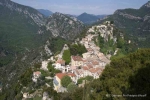
Most villages were built in the Middle Ages and their particularity is the location in height, positioned on rocky headlands.
Witness of the adaptation of human habitations to the marked relief of the territory, they were built this way to ensure also a defensive position.
The silhouette of the ancient villages could be preserved and cultural heritage is considerable: chapel Gratemoine in Séranon, ruined village of Gréolières, medieval church of Mas, architecture with Russian influence in Thorenc etc. Napoleon I crossed the territory on his return from Elba, on the road that now bears his name.
The Préalpes d'Azur permit the practice of a whole range of outdoor activities (hiking, mountain biking, horse riding, paragliding, climbing, whitewater, caving, via ferrata, summer and winter activities in the stations of Audibergue and Gréolières-the-snow, making it a favorite destination for active visitors.
In March 2012, fulfilling the desire of 45 municipalities, 8 village communities (EPCI), the department of Alpes-Maritimes, the region Provence-Alpes-Côte d'Azur, state, residents and professionals to work together; the territory has been awarded as Regional Nature Park.
He became the 48th Regional Nature Park of France and the 6th in the region Provence-Alpes-Côte d'Azur, constituting a crucial part of ecological continuity from the Camargue to the Mercantour.
|
Name of protected area |
Regional natural park of Azurian prealps |
|
Managing enterprise (if different) |
Mixed union of Regional natural park of Azurian prealps |
|
Country |
France |
|
Area (ha) |
88 944 ha |
|
Year of creation |
2012 |
|
IUCN category |
V |
|
Legal basis |
Territorial community |
|
Included regions |
Provence-Alpes-Côte d'Azur |
|
Number of municipalities |
45 |
|
Lowest point (m) |
90 m |
|
Highest point (m) |
Peak of Cheiron 1778 m of altitude |
|
Population |
31 272 inhabitants |
|
Forest surface |
60% du territoire soit 60 000ha |
|
Glacier surface |
0% |
|
Pasture surface |
Park represents 36% of all pasture surface of the Alpes-Maritimes department. |
|
Prevailing landscape types |
very diverse: karst plateaus, narrow valleys and gorges, mountain steppe and wide agricultural plains, cultivated terraces at the foothils, etc. |
|
Emblematic fauna |
Meadow viper |
|
Emblematic flora |
in the natural park is represented one third of all France flora |
|
Major touristic attractions |
village of Gourdon, known as one of the most beautifful villages in France |
|
Information center(s) (quanitity, name, topics) |
|
|
Internet site |
|
|
Number of employees |
7 |
|
Accès |
by car: highway Nice-Marseille, exit for Cannes/Grasse, then in dirrection of Grasse, or from the valley of Var by the Napoleon road (la route Napoléon), or from Puget-Théniers; by train: train stations in Grasse and Puget-Théniers |
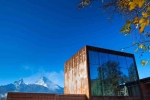
With this slogan Bavarian Minister President Seehofer and Minister of the Environment Huber officially inaugurated the “Haus der Berge” (Mountain House) in Berchtesgaden, Germany on 24th May last.
The “Mountain House” is intended as the gateway to the Berchtesgaden National Park . Here you will find information and important advice not only to prepare your visit but also to enhance your experience of the protected area.
The “Mountain House” does not replace a visit to the national park, but is an excellent beginning or ending to hikes in this unique treasure – the only Alpine national park in Germany!
The extraordinary architecture of the Mountain House, information and educational centre of the Berchtesgaden National Park, is based on a modern exhibition and an outdoor space, whose priority will be to raise awareness of the environment among children and teenagers.
Dr. Michael Vogel, Director of the National Park and president of the Alpine Network of Protected Areas (ALPARC) thus has at his disposal, after almost 10 years of planning and construction, one of the most excellent visitor centres in the Alpine protected areas, and Bavaria gains one more attraction.
It unites the Mercantour National Park (F) and the Alpi Marittime National Park (I) by means of the European Grouping for Territorial Cooperation (EGTC).
This park is the end product of 30 years of trans-border collaboration, 26 years of twinning, several simultaneous European programmes and a project of common listing in the UNESCO World Heritage encouraged by its recent inscription on the indicative lists of the two countries.
Some key figures from Mercantour – Alpi Marittime:
• 1, 000, 000 visitors per year in the two parks
• The inventory of its biodiversity has made it possible to increase the number of species recorded from 3,500 to more than 8,000 since 2006
• 40, 000 cave drawings from the Bronze Age in the Vallée des Merveilles
• 25, 000 inhabitants
• 2, 425 km² surface area
The National Park Mercantour , the Nature Park Alpi Marittime and the River Park Gesso e Stura created together the
within the framework of the Integrated Trans-border Plan (PIT) financed by the ALCOTRA European programme of trans-border coordination. The aim of this platform is to allow effective trans-border coordination between all the players of the trans-border territory. Its vocation is to facilitate working in this network and make available a larger number of tools and teaching resources.
As the high point, there is a space essentially devoted to teachers. To access this platform, simply go to the following site: www.edu.marittimemercantour.eu
For more information contact Elena Maselli (In charge of teaching/EEDD of the Mercantour National Park)
Pour préserver la traditionnelle COEXISTENCE DE L’HOMME ET DE LA NATURE et pour garantir la conservation des précieuses caractéristiques naturelles et culturelles de la vallée de Logar (Logarska Dolina) dans le futur, un décret a proclamé en 1987 la création du Parc paysager Logarska Dolina.
Un parc naturel est un paysage protégé dans lequel l’interaction entre l’Homme et la nature a produit, au fil du temps, un espace au fort caractère et avec des valeurs écologiques, biologiques, culturelles et paysagères remarquables.
La vallée de Logar a été protégée en tant que parc paysager en 1987 par un décret de proclamation des monuments naturels, culturels et historiques de la commune de Mozirje.
En 1992, les habitants de la région ont fondé la LOGAR VALLEY DEVELOPMENT COMPANY et obtenu de la municipalité locale le droit de prendre en charge la gestion du parc. Des taxes ont été instaurées sous forme d'une contribution à l'entretien de la vallée et de frais de parking; c'est la seule source publique de financement.
Aujourd'hui, le parc dispose d'un service pour la nature, de services de base et d’une infrastructure touristique (entretenue régulièrement), d’un système d'information pour les visiteurs, d’attractions touristiques durables (hiver et été) et d’un certain nombre de sites bien gérés d'intérêt naturel et culturel.
Logar Valley Lc. (Logarska Dolina d.o.o) dispose de 3 employés (garde-moniteur, agent de centre d'information et chef de projet).
Le territoire du Parc paysager Logarska Dolina se situe entièrement sur la commune de Solčava et s’étend jusqu’aux limites des communes de Jezersko, Kamnik et Luče (toutes localisées sur le Mont Ojstrica).
Le parc a une frontière commune avec l’Autriche (Gemeinde Bad Eisenkappel). L’espace protégé couvre la totalité du vallon glaciaire Logar et est une des sept vallées glaciaires des Alpes Kamnik-Savinja qui s’ouvrent vers le nord.
Il s’étend sur ses plus hauts sommets (Ojstrica 2350 m, Planjava 2394 m, Turska gora 2252 m, Koroška Rinka 2433 m, Mrzla gora 2203 m) et ses parois rocheuses (Okrešelj, Klemenča jama) puis serpente jusqu’au fond de la vallée, qui se termine par une moraine glaciaire au nord.
La rivière Savinja prend sa source dans la vallée de Logar, d’abord sous la forme des chutes du Rinka, qui disparaissent ensuite sous terre puis refont surface dans la partie basse de la vallée, en tant que rivière Črna. Cette dernière rejoint ensuite le Jezera pour devenir la rivière Solčava.
Il y a plus de 40 sites d'intérêt naturel enregistrés à Logarska Dolina, parmi lesquels des chutes d'eau, des aiguilles rocheuses, grottes, abris sous roche, blocs erratiques, des arbres de dimensions énormes, de la flore et de la faune. Le Rinka est l'une des plus hautes cascades de Slovénie (90 m).
La flore diversifiée du parc comprend notamment la rare orchidée renouée (Cypripedium calceolus), plus grande orchidée de Slovénie, et plusieurs espèces de plantes endémiques, dont la Céraiste des Alpes
juliennes (Cerastium julicum), Allium kermesinum (ail des Alpes kamniques) et Leucanthemum lithopolitanicum (marguerite des Alpes kamniques).
L'Aigle royal (Aquila chrysaetos) niche dans la zone plus large autour de Logar Dolina et la vallée abrite aussi le Faucon pèlerin (Falco peregrines).
Le sentier 7 KM Logarska Valley offre un parcours nécessitant environ deux heures de marche, un peu plus avec un guide (avec explications); sinon il est aussi possible de choisir un parcours plus court plus bas dans la vallée, à environ 730m d’altitude.
|
Nom de l'espace protégé |
Parc naturel Logarska Dolina |
|
Nom de l'organisme gestionnaire (si différent) |
Logarska dolina Lc. |
|
Pays |
Slovénie |
|
Surface (ha) |
44 km2 |
|
Année de création |
1987 |
|
Catégorie(s) UICN |
5 |
|
Statut juridique |
Sarl |
|
Région(s) couvertes |
Commune de Solčava |
|
Nombre de communes |
1 |
|
Point le plus bas (altitude) en m |
750 |
|
Point le plus haut (altitude) en m |
1200 |
|
Habité/non habité (si oui, population) |
60 |
|
Surface en forêt |
25 km2 |
|
Surface en glaciers |
0 |
|
Surface en pâturages |
19 km2 |
|
Principaux types de paysages |
Forêts, prairies |
|
Faune emblématique |
Chamois, cerf |
|
Flore emblématique |
Prairies de fleurs alpines |
|
Attraction touristique majeure |
Cascades de Rinka et Palenk, source de la Črna, orme, tilleul, Chapelle du Christ-roi |
|
Centre(s) de visiteurs (nombre, noms, thèmes) |
Office de tourisme (TIC) de la vallée du Logar |
|
Site Internet |
|
|
Personnel (nombre d'employés) |
3 |
|
Accès |
Autoroute A2, sortie Šentrupert, puis direction de Mozirje et Solčava pour la vallée du Logar. Ou depuis l'Autriche, Bad Eisenkappel par le col de Pavlič jusqu'à la vallée du Logar. |