La Rete delle Aree Protette Alpine
ALPARC invites you to discover or rediscover its latest publications.
This publication, conceived within the framework of a project in partnership with the Swiss Parks Network and funded by the Swiss Federal Office for the Environment (FOEN) , aims to improve the management of protected areas by helping managers to define the most appropriate and effective measures.
This catalogue of indicators is now available in the four Alpine languages and English. To consult without moderation!
Based on interviews with 21 alpine protected areas, the report “Renewable energies in Alpine protected areas” shows the conflicts between the protection and the use regarding the production of renewable energies as well as possible strategies. The study has been elaborated by the Swiss Academies of Arts and Sciences (SAS) with the support of the Alpine Network of Protected Areas (ALPARC) and has been funded by the Federal Office for the Environment (FOEN).
The report, available in a trilingual uncut version and a concise version in German, French or Italian, can be downloaded at: www.parkforschung.ch
We are pleased to provide you here a first list of events organized or co-organized by ALPARC and important dates to remember in 2012.
|
12-15 January |
|
|
1-2 March |
ALPARC International Steering Committee – Monaco (MC) |
|
4 September |
|
|
5-8 September |
|
|
17-18 October |
Workshop Mountain Environmental Education – Hohe Tauern National Park, Mallnitz (A) |
|
Other events and meetings could still be programmed. Don’t forget to check regularly the calendar of events at the website of Alparc. You can also stream your own events on this site, under " Events of the Alpine protected areas " and "Other events in the Alps ": for this, you have simply to provide us all useful information: info@alparc.org |
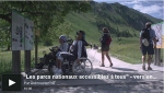
Since 2008, the French National Parks and the insurance company GMF are working together on a program to adapt the accessibility of the French national parks and taking into account the four different groups of disabled persons: physically, mental or visually handicapped and deaf-and-dump persons.
This ambitious program today includes 9 French National Parks:
Take a look at the video report!
The video is only available in French. Nevertheless, as demonstrated by the images, the video shows interesting opportunities for accessibility.
Source : The french national parks http://www.parcsnationaux.fr
20 partners , representing about 60 protected areas from 6 Alpine States, will present all together on the European Day of Parks, the 24th of May 2012, the multivision show of the Alpine protected areas network ALPARC .
With the duration of about 20 minutes, the multivision is addressed to a wide public and invites everybody, through music and pictures, to discover the diversity of the Alpine protected areas, the Alpine landscapes and cultures as well as its cultural heritage.
The 20 project partners will organise from the 24th of May on, a projection of the multivision show in their regions, especially during the following summer months. An Alpine-wide presentation of the multivison is planned for the Alpine Week , in September 2012.
Please notice that the multivison will be placed at the disposal of all protected areas of the ALPARC network for projection in each information centre and during events.
For further information or questions, please contact: marie.stoeckel@alparc.org
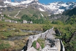
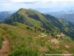
During the last Alpine Conference in March 2011 the Alpine Convention officially nominated 8 pilot regions for ecological connectivity in the Alps. One of these regions, the ecoregion Alpe Veglia ed Alpe Devero (Italy), has now been enlarged on both sides of the boarder in the area of the mythic Simplon.
Together the Swiss and Italian partners have started first steps to launch activities in favor of ecological connectivity following the common alpine approach developed by the Ecological Continuum Initiative and the Econnect project.
Besides the evaluation of the area carried out according to the criteria developed by the Platform Ecological Network of the Alpine Convention that could be finalized with success at the beginning of the year, an analysis is been realized with the online mapping tool JECAMI that will allow to define the potential of the area concerning ecological connectivity and to develop a list of concrete actions that should be started.
An important international event is planned for May 2012 that will bring together the most important actors of the area and that will also be the occasion to start the activities in synergy with all concerned sectors.
Photo description: Panoramic sight to the Alpe Veglia (village of Aione, 1752 m). In the front, an irrigation canal carved in a larch trunk.
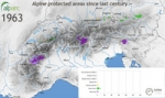
In the year 1914, the first Alpine national park was founded: the Suisse National Park . At the entrance of the valley Engadin, in the canton of Grisons, for almost 10 years the national park was the only protected area in the Alps. Then the National Park Gran Paradiso in Italy and the Triglav National Park in Slovenia followed.
Nature protection became more and more important. Some nature reserves were developed from the year 1925 on (the first one in the Triglav National Park), but the main part of the Alpine protected areas came out after 1952, the year of the foundation of the International Commission for the protection of the Alps (CIPRA).
Within the signing of the Alpine Convention in 1991, 6 Alpine countries, which have signed the convention, have already created 10 national parks, 46 regional nature parks, 235 nature protection areas and 139 special protected areas. Furthermore the UNESCO has recognised 5 protected areas as biosphere reserves.
Nowadays there are around 1000 protected areas (> 100 ha) united in the network ALPARC, in the perimeter of the Alpine Convention and its surroundings.
You can see the animation about the historical development of the Alpine protected areas at this link !
For further information, please look at our webpage (www.alparc.org) or contact us directly by mail: info@alparc.org .
30 of April 2012: bear M13 were run over by a train
The bear M13 survived the collision with the train of Rhätischen Bahn (RhB). By this incident, the GPS transmitter, the bear was equipped with, destroyed.
2nd of May: bear may be evidenced in Oberengadin
Rangers of the national park could find traces of a bear in the area S-chanf at the 2nd of May. One day later, the 3rd of May, traces were also found in Bever. So for the first time a bear could have been seen in Oberengadin. Until now it is not for sure which bear has been sighted. It cannot be excluded that it was the bear M13, which is still in Unterengadin since his collision with the train.
Communiqué de presse complet en allemand, 7 mai 2012
Suisse National Park

ALPARC is pleased to present the multivision "for the Alps", an audiovisual production built around more than 400 photographs painstakingly selected from the 10,000 shots taken and shortlisted by park officers in nearly 60 protected areas. These areas are represented by 20 management bodies who are full partners in this unique creative piece.
“For the Alps” pays visual tribute to the diversity found in the Alps: landscapes, cultures, habitats, lifestyles, and the potential for creating links between these areas that are slowly being fragmented.
Like a sensible and aesthetic testimony, “for the Alps” is the basic of the dialog between local actors, protected areas administrator and visitors. The multivision takes the viewer on an unusual journey through the Alps, travelling from the lofty mountain heights to inhabited areas, from East to West, North to South. It is like being picked up and carried along at the will of the four winds.
The production will be premiered on 24 May 2012, the European Day of Parks. Twenty protected areas in six Alpine countries will screen the multivision production created by Alex Gordon Rowbotham and set to original music by Sandro di Stefano.
You can find all the projection events and further information at this link.
The multivision « for the Alps » is a joint project of ALPARC and around 20 managers or networks of Alpine protected areas.
From the 24 of May on, this common communication tool will be distributed by all 20 partners in their territory over the whole summer season and it will be subsequently placed at the disposal of all Alpine protected areas.
Since 2011 ALPARC’s postcard collection increased thanks to the creation of additional cards of the following protected areas:
- the Alpine Park Karwendel , Austria
- the 9 nature reserves in Haute-Savoie, managed by ASTERS in France
- the Chartreuse Regional Nature Park , France
In addition, we have dedicated a postcard to the mulivision show “For the Alps” . This card exists in five languages and will be distributed by the organisers during the multivision projection. On the postcard’s backside you will find a web link that allows you to see the multivision show online (the multivision will not be on disposal for the public in DVD format. That’s why we offer the web link to all spectators and visitors of the parks information centres for giving them the possibility to watch the show at home).
The postcard collection has reached a high popularity among the public and shows in a simple but aesthetic way the diversity of the Alpine protected areas – not only each one individually but as well the connection within the network.
We would like to remind you, that all models of the postcards are available and free to print for all alpine protected areas.
After several premiere screenings of the multimedia show "For the Alps" , presented by the project partners throughout the European Day of Parks on 24 May 2012 in Berchtesgaden, Bled, Bohinj, Cevo, Chambéry, Domodossola, Embrun, Leuk, Matrei in Osttirol, Mojstrana, Mölln, Nice, Sondrio, St.Gallen/Steiermark, Trenta, Varzo, Vezza d'Oglio, Verbania… further demonstrations are planned by the partners and their protected areas during the current summer season, sporadic events, as well as regular demonstrations in the visitor centers in the parks.
ALPARC will present the multivision show in Poschiavo, Switzerland, from 5 to 8 September 2012, as part of the AlpWeek 2012 and its General Assembly . Following these events the multivision will be provided for free to all Alpine protected areas of the network.
We invite you to consult the website for the multivision show , to be informed about the latest presentation of the show in your area.
For further information, visit and look at :
- the last article: The multivision “For the Alps”: an original and unique audiovisual event
- the press release and list of partners can be found at the bottom of the attached documents
- and http://multivision.alparc.org .
Are you interested to present the multivision? Just send us a message to: multivision@alparc.org
They glide... a few wing beats, they slip between the trees to complete their flight on a hilltop. The birds. What do you think, how do birds feel when they see the Alps, drifting by under their wings during their migration in spring and autumn?
Fly with us on your area and take the opportunity to get the knowledge about the Alpine protected areas with our tool ViViAlp!
The tool ViViAlp, a virtual tour (in 3D) of the alpine protected areas, continues its development.
After 4 years of success in nearly two dozen information centres across the 6 alpine countries and as well online with the Google Earth version, it is now possible to find new Alpine protected areas and new 'points of interest' (POI): The Natural Park Nagelfluhkette (D), ASTERS (Natural Reserves Haute-Savoie) and the National Park Mercantour in France and as well the Natural Park Alpi Marittime (I).
Our partners of the project ALPENCOM, in which project ViViAlp has been created, such as the National Park Triglav and the City of Chambéry , will also incorporate new points of interests.
For more information please contact Stéphane Morel at the Task Force Protected Areas by email (stephane.morel@alparc.org) or phone : +33(0)4 79 26 55 09 or look at our homepage !
Established in 2008, the Nagelfluhkette Nature Park brings together communities in the southern Allgäu and the Vorderer Bregenzerwald. It is the first nature park to span the border between Germany and Austria. The communities contained in the protected area are all located in the renowned Nagelfluhkette range. The massif is mainly composed of Nagelfluh, a conglomerate made from innumerable riverbed pebbles of varying sizes which have been compacted to form the rock. The most famous peak is the Hochgrat (1,834 m) which rears up more than 1,000 m above the surrounding valleys. The Nagelfluhkette Nature Park is home to many valuable species, including capercaillie, black grouse, golden eagles, white-backed woodpeckers and mountain apollos.
Because of the area's geological diversity, the deep soil layers can be both chalky and sandy. Consequently, the plant life is incredibly rich and varied. As well as Alchemilla cleistophylla (Allgäu lady's mantle), a plant endemic to the protected area, plant-lovers will find purple gentian, wood pinks and noble silver firs.
The Nagelfluhkette is an area of established, mature farmland which is surprisingly well preserved given its location on the edge of the northern Alps. This reflects the importance of agriculture, with around 400 farmers, many of whom use Alpine farming practices which have shaped the landscape. There is an unusually high proportion of grazing meadows on both sides of the border.
Alongside agriculture and forestry, tourism has been a mainstay of the area covered by the natural park for the last century. The 14 communities within the protected area have an impressive 20,000 beds on offer in hotels, guesthouses and holiday homes in order to cater for around 2.5 million overnight stays each year.
The new management body has a lot on its plate. The currently priorities are developing sustainable tourism products (top quality walking paths and networks of paths); setting up environmental education activities (programme of walks and field trips, information points); promoting sales of regional products (partnership scheme), and providing practical support for sustainable regional development. The management body is based in Oberstaufen, Germany, and is responsible for the whole nature park, including the parts in Austria. The management board and committees all contain representatives from both sides of the border which is beneficial for joint development projects.
Rolf Eberhard, director
Contact details:
Naturpark Nagelfluhkette e.V.
Schloßstraße 8
D-87534 Oberstaufen
Tel. 0049 8386 9300 -328 begin_of_the_skype_highlighting 0049 8386 9300 -328 end_of_the_skype_highlighting
Fax. 0049 8386 9300 -339
info@naturpark-nagelfluhkette.eu
|
Name of the protected area |
Naturpark Nagelfluhkette (nature park) |
|
Managing organisation (if different) |
Naturpark Nagelfluhkette e.V. |
|
Country |
Germany / Austria |
|
Area (ha) |
40100 |
|
Year of creation |
German part on the 1st of january 2008, Austrian part on the 27th of may 2008 |
|
UICN category |
none |
|
Legal basis |
In Germany: Natural park (reconnu) |
|
Included regions |
Germany: Allgäu, in the state of Bavaria |
|
Number of municipalities |
14 |
|
Highest point (m) |
465 |
|
Lowest point (m) |
2050 |
|
Population |
around 13 000 residents |
|
Forest surface |
around 20900 ha |
|
Glacier surface |
0 |
|
Pasture surface |
around 8140 ha |
|
Prevailing landscape types |
Mixed mountain forest, subalpine spruce forest, alpine pastures, high and low marshes, forest gorges, natural ground running water |
|
Emblematic fauna |
Western Capercaillie, Black Grouse, Hazel Grouse, Golden Eagle, Eurasian Three-toed Woodpecker, Apollo (butterfly), Red Deer, Chamois |
|
Emblematic flora |
Alchemilla, Dianthus sylvestris, Gentiana, Silver Fir |
|
Major touristic attractions |
Mountain chain Nagelfluhkette, lake Alpsee, cave Sturmannshöhle, ecomuseums Frauenmuseum and Juppenwerkstatt |
|
Information center(s) (quanitity, name, topics) |
From the end of next year, information center Lake house (AlpSeeHaus) will be opened in Immenstadt, other information points are in construction on the top stations of the cable cars. |
|
Website |
|
|
Number of employees |
1 |
|
Access |
Nearest train stations : Bregenz, Oberstaufen, Immenstadt, Blaichach ou Fischen, and bus |