Le Réseau Alpin des Espaces Protégés

La Stratégie Biodiversité Suisse aspire, d’ici à 2020, à une société ayant suffisamment de connaissances sur la biodiversité pour être en mesure d’en prendre compte dans les décisions importantes.
Mais comment motiver les acteurs concernés d’intégrer la conservation et la promotion de la biodiversité dans leurs actes quotidiens ? Que faut-il savoir, et quel rôle jouent les valeurs, les images de la nature ou les possibilités de participation ? Ces questions seront abordées au congrès SWIFCOB 13 «La biodiversité, comprendre pour mieux agir» du Forum Biodiversité Suisse de la SCNAT à l’aide de théories modernes et d’exemples modèles implémentés. Nous vous invitons à vous inscrire pour une participation ou pour un stand à notre marché :
www.biodiversity.ch/f/events/swifcob/
SWIFCOB – Dialogue entre acteurs de la biodiversité
Le Swiss Forum on Conservation Biology SWIFCOB réunit les différents acteurs des sciences et de la société dans le domaine de la biodiversité. Le congrès est une plate-forme d’échange dédiée aux défis à relever en matière de biodiversité. En outre, SWIFCOB a pour vocation de susciter le débat autour de sujets d’actualité liés à cette thématique. Le Forum Biodiversité Suisse de l’Académie des sciences naturelles (SCNAT) organise chaque année le congrès avec le soutien et la collaboration de différents partenaires.
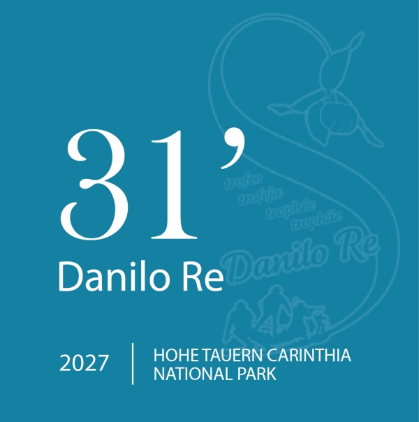
The Vanoise National Park (F) in collaboration with the city of Pralognan-la-Vanoise and ALPARC organises from Thursday 17th to Sunday 20th of January 2013 the 18th edition of the Danilo Re Memorial, dedicated to a ranger of Cuneo region who died during the exercise of its functions in 1995. The " Danilo Re Memorial" represents an important opportunity for all staff of alpine protected areas to meet.
More information at: http://www.danilo-re.net
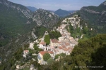
Between the prestigious Riviera and the high mountains of the Mercantour, this mountainous territory, composed of karst plateaus, gorges, forests and fertile valleys, the Préalpes d'Azur is still relatively unknown. There is a rural culture reigning, around picturesque, alive and convivial villages.
This is one of the territories of France's richest biodiversity; a third of the French flora is present there, the result of thousands of years of interaction between man and nature and always closely linked to the maintenance of pastoral activity.
The crossing of the Mediterranean and Alpine influences, together with an area which was preserved of major developments, make it exceptional. Added to this no less than 2000 caves and 140 km of underground tunnels form the accessible part of the vast underground network, so the Préalpes d'Azur are a real water reserve for the Côte d'Azur.
Historically, people lived by agriculture, forestry and pastoralism. Later, when the perfume industry grows in Grasse, this area lives in the rhythm of fragrant plants culture.
Currently, agricultural activity is still present, although fragile; sheep, cows, goats graze the heath-and woodland.
Most villages were built in the Middle Ages and their particularity is the location in height, positioned on rocky headlands.
Witness of the adaptation of human habitations to the marked relief of the territory, they were built this way to ensure also a defensive position.
The silhouette of the ancient villages could be preserved and cultural heritage is considerable: chapel Gratemoine in Séranon, ruined village of Gréolières, medieval church of Mas, architecture with Russian influence in Thorenc etc. Napoleon I crossed the territory on his return from Elba, on the road that now bears his name.
The Préalpes d'Azur permit the practice of a whole range of outdoor activities (hiking, mountain biking, horse riding, paragliding, climbing, whitewater, caving, via ferrata, summer and winter activities in the stations of Audibergue and Gréolières-the-snow, making it a favorite destination for active visitors.
In March 2012, fulfilling the desire of 45 municipalities, 8 village communities (EPCI), the department of Alpes-Maritimes, the region Provence-Alpes-Côte d'Azur, state, residents and professionals to work together; the territory has been awarded as Regional Nature Park.
He became the 48th Regional Nature Park of France and the 6th in the region Provence-Alpes-Côte d'Azur, constituting a crucial part of ecological continuity from the Camargue to the Mercantour.
|
Name of protected area |
Regional natural park of Azurian prealps |
|
Managing enterprise (if different) |
Mixed union of Regional natural park of Azurian prealps |
|
Country |
France |
|
Area (ha) |
88 944 ha |
|
Year of creation |
2012 |
|
IUCN category |
V |
|
Legal basis |
Territorial community |
|
Included regions |
Provence-Alpes-Côte d'Azur |
|
Number of municipalities |
45 |
|
Lowest point (m) |
90 m |
|
Highest point (m) |
Peak of Cheiron 1778 m of altitude |
|
Population |
31 272 inhabitants |
|
Forest surface |
60% du territoire soit 60 000ha |
|
Glacier surface |
0% |
|
Pasture surface |
Park represents 36% of all pasture surface of the Alpes-Maritimes department. |
|
Prevailing landscape types |
very diverse: karst plateaus, narrow valleys and gorges, mountain steppe and wide agricultural plains, cultivated terraces at the foothils, etc. |
|
Emblematic fauna |
Meadow viper |
|
Emblematic flora |
in the natural park is represented one third of all France flora |
|
Major touristic attractions |
village of Gourdon, known as one of the most beautifful villages in France |
|
Information center(s) (quanitity, name, topics) |
|
|
Internet site |
|
|
Number of employees |
7 |
|
Accès |
by car: highway Nice-Marseille, exit for Cannes/Grasse, then in dirrection of Grasse, or from the valley of Var by the Napoleon road (la route Napoléon), or from Puget-Théniers; by train: train stations in Grasse and Puget-Théniers |
|
The Alpine network of protected areas, that means we all together, must continue to develop, to think future-oriented and to be even more powerful and assertive. For this we need you all. |
||
|
ALPARC needs a legal basis and structure in order to be able to implement larger shared projects, but also and above all in order to give a greater image and international weight to the protected areas of the Alps. The principal leitmotiv, however, remains the provision of concrete, efficient and grounded contributions towards the application of the Alpine Convention and its protocols, especially as regards the “Protection of nature and safeguarding of landscapes”. |
||
|
The last General Assembly , which took place in Poschiavo /CH on 7th of September 2012, was marked by a common declaration of the present protected areas, indicating their intention to create an association ALPARC: “Aware of the ecological, economic and social stakes, and appealing for a better coordination and coordination of the actions implemented throughout the Alps, the protected Alpine areas and territorial communities signing the present declaration have decided to pool their reflections in order to create the ‘ALPARC – Alpine Network of Protected Areas’ association, a tool of Alpine cooperation”. |
||
|
The date of this constitutive assembly is now scheduled: it will take place on Friday morning, 18th of January 2013, in the heart of one of the big alpine protected areas event, the Danilo Re Memorial, organised for this 18th edition by the Vanoise National Park in Pralognan–la–Vanoise /F. |
The founding members of the association will be exempt from admission fees.
Please confirm your participation at this important assembly by simple e-mail to info@alparc.org before 21st December 2012. The documents referring to the agenda will be sent after your registration.
|
9.00 a.m. |
Welcome by the President and Vice-presidents of the International Steering Committee ALPARC |
|
Welcome by the Director of the Vanoise Nationalpark |
|
|
Welcome from the French Authorities |
|
|
9.30 a.m. |
History, evolution and objectives of ALPARC |
|
10.00 a.m. |
Proposal of Statutes and Internal rules, short discussion |
|
10.30 a.m. |
Proposal of a first framework program 2014-2020 |
|
11.00 a.m. |
Creation of the association by membership declarations |
|
11.30 a.m. |
Election of the Council of ALPARC |
|
12.00 a.m. |
Festive session and media release |
The Constitutive Assembly will take place during the Danilo Re Event. The morning of the 18th is not covered by competitions of the Trophy and gives the opportunity to all protected areas managers, or representatives, to join the meeting.
In the context of the ALPARC “Mountain Environmental Education” Working Group, Alpine Protected Areas (APA) Education project leaders met in Mallnitz in the Hohe Tauern National Park from 17th to 19th October 2012. This second international meeting was organised by ALPARC in partnership with the REEMA and the host park.
This second international meeting was organised by ALPARC in partnership with the REEMA and the host park. It was an opportunity to exchange ideas on different perceptions of mountains and the Alps, to enhance practices and to consolidate ties.
Several leads for common projects throughout the Alpine arc emerged from this workshop which showed once again the complementary nature of the partnership between the REEMA and ALPARC.
"Hans Keuschnig and Birgit Wirnsberger, from the Hohe Tauern National Park, gave us a very warm welcome in their magnificent Centre de visiteurs BIOS (Besucherzentrum BIOS) in Mallnitz. Common goals and the first lines of collective action in this field were defined thanks to presentations of experiences concerning young people and mountains, a forum about tools to help them to find out about the alpine heritage and collective thinking around the relationship between young people and mountains today.
But how can we not mention the discovery of local products from each park taking part, the magnificent visit to the “BIOS” National Park Centre, the beautiful excursion in the Seebachtal during which Michael Knollseisen, a park ranger, let us observe a couple of bearded vultures……. in short, everything that makes the meetings of the alpine protected areas in Europe so rewarding.
As always, Isabelle Roux for the REEMA and Marie Stoeckel and Guido Plassmann for ALPARC together led this three-day workshop in masterly fashion, combining depth of collective thinking and human warmth during this precious time spent together. German, Italian, French and Slovene resounded in unison with help from English , of course, but beautifully united and whose fruits you will discover in the information about the 2013/2014 programme which will be proposed to the administrators of the Alpine protected areas.
To close, a visit to Mitterstill allowed all the education project leaders to discover a new way of going over passes with cars on goods wagons and, above all, a fantastic second Visitor Centre in the National Park , as recent, ambitious and spectacular as it is educational.
A magnificent synthesis of our work, these two visitor centres combine the most modern technology and supports to put across the cultural, natural and landscape heritage of the Alps. What a lesson!"
Claude Dautrey - Parc national des Ecrins, participant
If you are in charge of environmental education in an alpine protected area and are interested in the work of this group open to all, do not hesitate to contact Marie Stoeckel so that your name can be added to the list of group members and you can access the shared documents and results of these meetings.
Progetto Interreg Italia-Svizzera GREAT - Grandi Erbivori negli Ecosistemi Alpini in Trasformazione
Programma di Cooperazione Transfrontaliera Italia-Svizzera 2007-2013 Unione Europea FESR
under the endorsement of:
Alpine Network of Protected Areas ALPARC
IUCN Caprinae Specialist Group
The Gran Paradiso National Park and the Swiss National Park are pleased to invite you to the 22nd Meeting of the Alpine Ibex European Specialist Group - Gruppo Stambecco Europa (GSE- AIESG) that will be held in Zernez (Swiss National Park) on 26-28 October 2012.
The aim of the meeting is to update the knowledge on the status and distribution of Alpine ibex and to share the results of the latest research on this species. The conference is open to researchers, experts, managers and to everybody interested in this species.
SCIENTIFIC PROGRAMME
The scientific programme will include invited lectures, contributed talks and posters. The programme will be divided into a session on the s tatus and distribution of Alpine ibex populations and various thematic sessions on genetics, population ecology, behaviour, physiology, diseases and conservation.
The tentative schedule of the meeting will be as follows:
26 october, afternoon: Opening of the meeting and session: Overview on status and distribution of populations
27 october, morning and afternoon: Thematic sessions.
28 october, morning: Excursion in the Swiss National Park and closing of the meeting.
The session overview on status and distribution of populations will include only invited lectures (one contribution for each nation where the species is present with the aim to present the general situation of that country).
OFFICIAL LANGUAGE
The official languages of the meeting will be Italian, German, French and English. Translation services will be provided.
REGISTRATION AND SUBMISSION OF CONTRIBUTIONS
The deadline for registration and submission of contributions is 31st August 2012. Registration to the meeting is free but only delegates who registered before the deadline will be allowed to attend. To register to the meeting please fill the online registration form.
Delegates who want to present a contribution are asked to send a brief abstract (max 250 words) including title, authors and affiliations, type of contribution (oral presentation or poster), in english language along with the online registration form. Each speaker will have 15 minutes available for their presentation and 5 minutes for questions. Delegates will receive a confirmation of their registration and submission within two weeks after the deadline.
HOW TO REACH THE MEETING AND ACCOMODATION
Swiss National Park is easily accessible with public transport or by car, instruction on how to reach Zernez are available at http://www.nationalpark.ch/go/en/visit/how-to-get-there/
Zernez offer a wide range of hotels for accommodation, a list of hotels will be provided with the second announcement to all registered delegates.
The Second announcement, with informations on accommodation and the detailed programme, will be sent only to delegates registered before the deadline.
Hoping in a wide participation we look forward to your registration and to welcome you in Zernez!
ORGANIZING COMMITTEE
Bruno Bassano (Gran Paradiso National Park)
Flurin Filli (Swiss National Park)
Achaz von Hardenberg (Gran Paradiso National Park)
Ruedi Haller (Swiss National Park)
Alice Brambilla (DISTA, University of Pavia, Italy)
Seraina Campbell (Swiss National Park)
CONFERENCE SECRETARIAT
Ente Parco Nazionale Gran Paradiso
Servizio sanitario e della ricerca scientifica
Via della Rocca, 47 - 10123 – Torino (Italy)
tel. +39-11-8606211
e mail address for correspondence: gse@pngp.it
- Strategies for the Alpine Region -
Conference location: Bavarian Academy of Sciences and Humanities
Alfons-Goppel-Str. 11
80539 München, Germany
Le Conservatoire du Littoral, en partenariat avec Asters, organise les 19 et 20 octobre prochains à l’Impérial d’Annecy un colloque intitulé : « La France des Grands Lacs : un patrimoine à préserver ». Grand témoin : Jean Marie Pelt, Président de l’Institut européen d’écologie. Animateur : Jean Jacques Fresko, Rédacteur en chef du magazine Terres Sauvages.
Objectif : effectuer un tour d’horizon des enjeux et des problématiques liées à la protection et à la gestion des sites lacustres métropolitains.
Au programme : conférences, témoignages et découverte en bateau du lac d’Annecy
A cette occasion, nous serions heureux de vous compter parmi nous. Aussi, vous trouverez un programme prévisionnel.
Pour plus d'informations, vous pouvez contacter: bonnet.leila@orange.fr
The second Alparc workshop on the topic "Mountain Environmental Education: how to reinforce the relation between young people and Alpine mountain?" will take place from 17th to19th October 2012 in Mallnitz, in the Hohe Tauern National Park .
It is co-organised with the Hohe Tauern National Park - Carinthia and with the REEMA (Alpine Network for Mountain Environmental Education), which already gathers the staff in charge of environmental education in the French Alpine protected areas.
Target public: Staff in charge of environmental education in the Alpine protected areas.
Limited number of participants: 30 persons max.
Language of the meeting: English
Programme proposal: see document below (for download)
Main topic will be: YOUTH and MOUNTAIN: how to reinforce the relation between young people and mountain? Which ideas, tools, international projects
Parallel work sessions in small groups:
- Experiences of sponsoring, cooperations with external partners financing environmental education programs
- Education centres: experience of alpine protected areas with visitor centres (management, staff, costs, infrastructure, content and pedagogical material, impacts, selling products or not?)
- Educational values, alpine culture and mountain identity
The programme will also offer large discussion time for informal experiences exchanges as well as various guided visits.
Contact:
ALPARC Education Working Group Coordination: marie.stoeckel@alparc.org +33 (0)4 79 26 55 00
Please find below the registration form as well as useful practical information. To register, fill in the form and send it back before 30th of SEPTEMBER 2012. Thanks!
From 17th to 19th October 2012 will be held an international conference on “Vegetation Prodrome of Europe”, in IGN headquarters, in Saint Mandé (94), France.
This conference is co-organized by the Société Française de Phytosociologie (French Society for Phytosociology) and the Ministère de l’Écologie, du Développement Durable et de l’Énergie (Ministry for Ecology, Sustainable Development & Energy), in the context of the revision of the Prodrome of the vegetation of France, started in 2006.
These two days will be the occasion to present the status of progress the vegetation prodrome of France and the declination of the classes to the level of associations. The participation of vegetation prodrome of France to build a synsystem of vegetation of Europe will be discussed too. Then the use of the results of the prodrome in the CarHAB program will be discussed.
Participation to this conference is open to all and requires mandatory registration (due to limited space). Online registration is available through www.geoarchi.net/prodrome webpage.
For further information please contact prodrome@geoarchi.net
Jean-Louis Joseph, président de la Fédération des Parcs naturels régionaux de France et Bernard Clap, président du Parc naturel régional du Verdon, ont le plaisir d'annoncer l'édition 2012 du Congrès des Parcs qui se tiendra du 10 au 13 octobre. En cette année du 45e anniversaire du 1er décret instituant les Parcs naturels régionaux - le Parc du Verdon —qui fête lui son 15e anniversaire— a été choisi pour accueillir cet événement qui réunit chaque année près de 1000 personnes issues du réseau des Parcs, en présence de délégations étrangères, de ministres et hauts responsables de l'Europe, de l'Etat et des Régions.
Cette année, c'est sous le titre « Projets partagés, territoires vivants » que le Congrès abordera du 10 au 13 octobre, les questions de la participation citoyenne, de la gouvernance, de la coopération, de la solidarité et du lien social, de la relation entre le public et le privé, d'alternatives économiques et sociales…
En cette année internationale des coopératives, les Parcs démontrent aussi que, s'ils sont un lieu privilégié de débat local, ils favorisent également l'appropriation des enjeux de niveau national et européen.
Autant d'enjeux essentiels pour les Parcs naturels régionaux qui ont toujours favorisé la pratique du « faire ensemble » qui fait aujourd'hui la force du réseau des 48 Parcs.
Depuis 45 ans maintenant, les Parcs ont développé la participation citoyenne en associant non seulement les habitants, mais tous ceux qui y travaillent, "consomment" ou fréquentent leurs territoires.
Ce congrès dans le Parc du Verdon sera l'occasion de mieux faire comprendre ce qu'est un Parc naturel régional, comment il fonctionne et aussi - qu'il n'y aurait pas de véritable Parc sans participation de la population, sans l'implication des acteurs locaux !
Et parce que cela ne se décrète pas mais se sème et se nourrit - il faut donner à chacun les moyens de s'informer, de comprendre, d'exister pour pouvoir trouver sa place et la motivation à s'impliquer ou à coopérer. Moment fort de la vie des Parcs en terme d'échanges, de débats, de convivialité, le Congrès est aussi un temps de réflexion collective et de production d'idées nouvelles pour construire l'avenir des Parcs en s'enrichissant des expériences du réseau mais également de celles menées ailleurs.
Chercheurs, experts, responsables de Parcs, élus - tous acteurs de nos territoires - déclineront tous ces aspects dans les ateliers, les circuits et les plénières.
Contact presse : Géraldine Falek - gfalek@parcs-naturels-regionaux.fr
Conférences, ateliers, films et débats, avec la participation de Nicolas HULOT.
Le 8 octobre : soirée dédiée aux Réserves naturelles de Haute-Savoie, avec le directeur d'ASTERS et la projection du film "Les Alpes, les sommets de l'extrême".
Programme complet en ligne (PDF)
Plus d'informations: www.rencontresalpines.org